How can you get your little ones interested in geography without turning the living room into a stern classroom? 🌍 An illustrated world map for kids to print is a fun, instant way to turn their walls into a window onto the continents. This visual aid is bursting with animals and famous landmarks that lock spatial landmarks firmly into their memory while gently decorating their bedroom.
- Why a large-format kids’ world map helps learning
- Designs suited to each stage of growing up
- Print at home or ready-made wall décor
- Quality and durability for little explorers
- Tips to personalise and fit the map to the room
- Turning the map into a playground
🗺️ Why a large-format kids’ world map helps learning
Once you’ve picked the right spot, it’s fascinating to see how a simple visual aid turns learning geography into a daily adventure for your child.
🌍 Naturally memorising the continents and oceans
A child’s brain picks up the shapes of the continents through simple visual exposure. Distinct colours, like red or green, help to tell each landmass apart with ease.
Spotting the oceans becomes second nature over time. Repeated exposure fixes the names in long-term memory with no effort at all. That’s the real benefit of learning through decorative immersion.
Having these landmarks constantly in the bedroom makes the names much easier to remember.
🔭 Sparking geographical curiosity from a very young age
Distance becomes concrete with a large-format aid. Seeing the world big helps a child grasp the sheer size of the Earth and its incredible variety.
Open-mindedness grows as young explorers take in this wider view of the world. Every coloured zone invites a thrilling new cultural discovery.
The map makes an ideal starting point for chatting about upcoming trips or world news as a family.
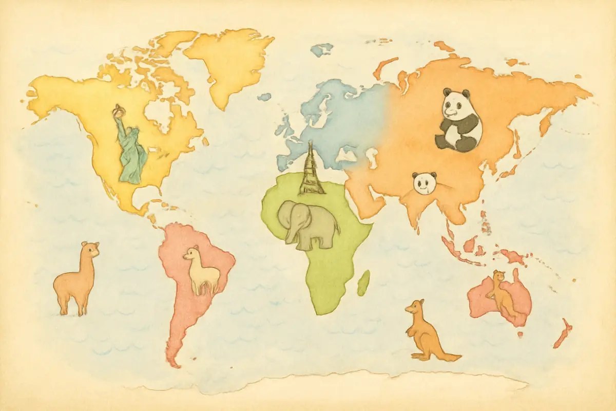
🐘 Visual cues for placing animals and landmarks
Linking a panda or a lion to its climate zone creates solid geographical anchors. The child connects the animal to its natural habitat in a very concrete, memorable way.
Famous landmarks, such as the Eiffel Tower or the Pyramids, make countries easy to recognise. These icons turn an abstract map into a lively, captivating story for little ones. An illustrated world map for kids to print then becomes a real treasure.
The illustration is the essential bridge between a child’s imagination and the precise reality of world geography.
👶 Designs suited to each stage of growing up
If the benefits are clear, the choice of design absolutely must follow the cognitive growth and changing tastes of your little explorer.
🦒 Playful illustrations and animals for under-5s
Bright colours and simple shapes come first. The drawings should be easy to recognise. This stops the visual attention of the youngest ones from being overloaded as they explore.
Using expressive animal icons helps a lot. Here’s what works best for them:
- Cute animals placed on their habitats.
- Contrasting primary colours to catch the eye.
- A round, very readable typeface.
The labels should stay minimal. The aim is sensory awakening and visual recognition above all else.
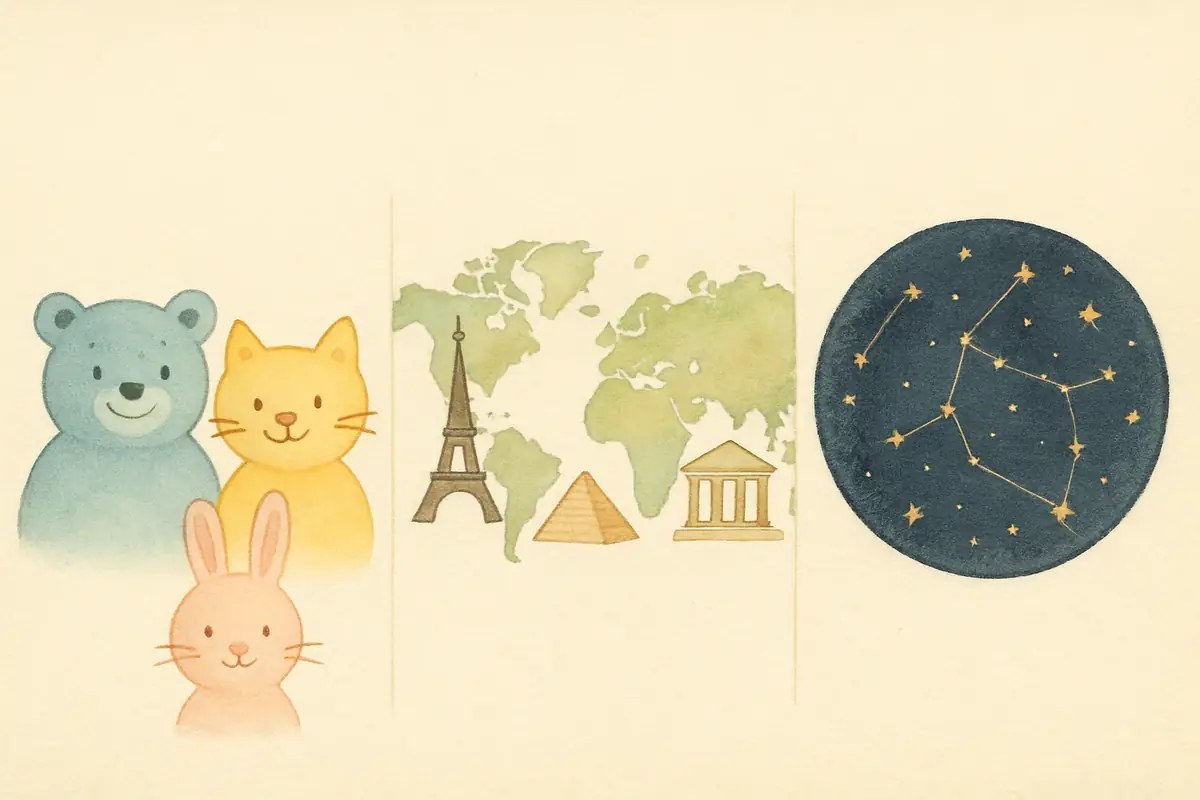
🏛️ Detailed maps with landmarks for primary school
This is the moment to introduce national borders and capital cities. At this age, the child learns the official names at school. The wall map then becomes a fun, effective revision aid.
Adding historical elements enriches the experience. Castles, temples and ships help to link geography to the history of civilisations. It’s a colourful approach that often grips pupils.
The graphic style stays appealing. You keep a balance between accuracy and a child-friendly look.
✨ Clean styles or constellations for teenagers
Now for the shift towards minimalism. Teenagers often prefer black and white or vintage tones. These choices suit a calmer, more grown-up bedroom décor better.
Exploring star maps and constellations is a great idea. This original theme keeps a link with discovery. It’s an elegant alternative to the classic flat map for an older child’s room.
The final look gains real character.
A clean design turns the educational map into a genuine piece of contemporary wall art.
🖼️ Print at home or ready-made wall décor
Once the style is settled, the technical question comes up: should you go for the flexibility of digital or the presence of a professional product?
💻 The perks of a digital file you print yourself
A downloadable file offers instant satisfaction. You can print it in a few minutes at home or at a local print shop for a low cost.
Flexibility is the main advantage. If it tears or gets scribbled on, you simply run off a fresh print. It’s the ideal solution for parents who love DIY and frequent refreshes.
Choose thick paper (180 gsm minimum). This ensures better durability and the best possible colours.
🖼️ The quality of ready-to-hang posters, canvases and wallpapers
Professional supports like canvas offer a fine texture. The colours are deeper and stand up better to natural sunlight.
Panoramic wallpaper creates an instant “wow” effect. It turns a whole wall into a window onto the world, perfect for total immersion.
| Support | Durability | Visual result | Setting up |
|---|---|---|---|
| Poster | 3/5 – Standard | 4/5 – Very sharp | 5/5 – Super simple |
| Canvas | 5/5 – Sturdy | 5/5 – Artistic | 4/5 – Hook needed |
| Wallpaper | 4/5 – Durable | 5/5 – Immersive | 2/5 – Tricky to hang |
Quickly comparing the professional supports lets you choose based on the intended use in the bedroom.
💰 Comparing cost and ease of setting up
DIY is unbeatable on the initial price. Even so, buying a finished product guarantees easier hanging and fixing accessories that are often included.
To fix it without damage, use adhesive tabs or magnetic wooden rails. These tips let you move the illustrated world map around as the furniture changes, without leaving marks.
Estimating the time is useful. Ready-to-hang takes ten minutes, against an hour for a carefully done home print.
🧭 Quality and durability for little explorers
Beyond looks and price, the safety and resistance of the materials remain non-negotiable criteria for a child’s bedroom.
🌿 Why non-toxic, odourless inks matter
Check environmental labels like Greenguard or Oeko-Tex. These certifications guarantee there are no volatile organic compounds that could harm little ones’ breathing. It’s a real peace of mind.
Water-based inks are absolutely the ones to go for. They give off no unpleasant chemical smell once hung. This point helps to ensure healthy sleep in a room closed all night. Your children breathe easier.
Safety comes down to the choice of components. Never overlook this technical aspect when you buy.
🧽 Wipeable coatings to stand up to pencil marks
A laminated or plastic-coated finish is a real lifesaver. It lets you wipe off finger or felt-tip marks with a simple damp sponge. No more stress about stains.
Tear resistance is also crucial. Children love to touch and handle the details. A sturdy support will cope with frequent handling without fraying or tearing at the slightest knock. It’s solid stuff.
To keep your illustrated world map looking like new, use:
- A microfibre cloth.
- Soapy water.
- A magic eraser for stubborn marks.
🌐 Accurate outlines and names in your own language
A map must stay a reliable tool. Even when illustrated, the geography has to be correct so it doesn’t mislead the child about where countries really are. Scientific accuracy counts too.
Language is key. Make sure the names of the oceans and continents are correctly written in your child’s language to support schoolwork and help with spelling. It’s so much simpler for them.
To go further, look into resources on using maps for teaching. These tools support the awakening of the world’s future citizens.
🛏️ Tips to personalise and fit the map to the room
For this tool to truly become your child’s own, a few personal touches will make all the difference in how they make the space their own.
🏷️ Adding the name for a truly unique object
Writing the child’s name creates a strong emotional bond. The map is no longer just a poster, but becomes their own personal land of exploration and dreams.
Choose a font that matches the graphic style. Cursive writing brings softness, while a block font reinforces the adventurous feel. It’s a detail that hugely adds value to the final object.
A sense of belonging boosts interest. The child will be proud to show “their” map to friends.
📏 Choosing the size to suit the available wall space
Measure your wall carefully before ordering. A map that’s too small will get lost in the space, while a giant format could overwhelm a little bedroom.
The ideal spot is often above the desk or the bed. The details need to be at eye level to guarantee perfect readability. Remember to leave room to move around.
A panoramic format is perfect for big walls. It offers a spectacular, immersive overview.
🎨 Matching the colours to the existing furniture
Harmonise the map’s tones with the bedroom textiles. If the walls are neutral, a colourful map will bring the room the energy it needs.
The choice of support also matters for the style. A natural wood frame echoes Scandinavian furniture, while a frameless canvas suits a modern feel better. The whole thing should stay soothing and coherent.
Keep an overall visual unity. The illustrated world map should fit in naturally without creating too harsh an aesthetic break.
🎲 Turning the map into a playground
Finally, a map isn’t meant to stay frozen on the wall; it’s the starting point for a thousand fun adventures to share as a family.
🧭 Setting up a treasure hunt around the continents
Make up riddles to find specific places. “Where is the kangaroo hiding?” or “Find the country with the Great Wall.” It’s an excellent spotting exercise.
Use repositionable stickers to mark the stages of the game. This lets you picture the route taken without damaging the support. That way you can build mental maps through play very easily.
The speed of the search keeps the child engaged. They learn while having fun with their parents.
🦁 Creating a discovery corner with animal figurines
Place animal figurines at the foot of the wall map. The child then has to find the natural habitat of each toy on the illustrated map, to make a concrete link.
Spark the imagination by making up epic travel stories. “The little elephant wants to go and see the penguins — which way should it go?” It’s a great foundation for language.
You can use different accessories to enrich the experience:
- Animal figurines
- Little paper boats
- Miniature flags to pin on
🌙 A bedtime ritual for telling travel stories
End the day by picking a destination at random. Tell a little story about the local customs or the extraordinary landscapes you can find there.
This calm moment encourages escape and dreaming before sleep. The child drifts off with images of faraway lands in mind. It’s a wonderful alternative to the classic stories read from fairy-tale books.
The map becomes a way to pass on knowledge. It opens a window onto the world every evening.
This illustrated world map for kids to print turns the bedroom into a magical land of exploration. By pairing animals and landmarks, it locks the continents firmly into the minds of your little adventurers. Download your map now to give your child a daily journey towards knowledge and wonder.
❓ FAQ
🌎 Why choose an illustrated world map for my child?
It’s a wonderful tool for turning geography into a visual adventure. Unlike a classic flat map, the illustrations of animals, landmarks and traditional costumes catch the youngest ones’ attention and make it easier to memorise the continents.
A large-format map also makes it easier to picture the vastness of the oceans and where the countries sit. It’s an aid that naturally sparks curiosity and open-mindedness, while nicely decorating the bedroom or playroom.
👶 From what age can you use a printable map?
You can start as early as nursery age, around 3 or 4, with very colourful designs focusing on animals and simple shapes. At this age, the aim is mainly sensory awakening and visual recognition of the large landmasses.
For primary-school children, go for more detailed maps including borders, capitals and famous landmarks. It then becomes a fun revision aid that perfectly rounds off their schoolwork.
📥 What are the advantages of a downloadable digital format?
The print-it-yourself format offers great flexibility and instant satisfaction. It’s an economical solution that lets you run a fresh print in a few minutes if the map is accidentally scribbled on or torn by an over-enthusiastic little explorer.
It also lets you choose your own support, like thick paper of at least 180 gsm for better durability. It’s the ideal option for parents who love DIY and want to adapt the print size to the space on their walls.
🌟 Are there maps suited to the Montessori method?
Yes, some maps are specifically designed for teaching approaches like the Montessori method. They often include pieces to assemble, cut out or match up, such as flags or animal figurines to place in the right spot.
The idea is to make learning tactile and interactive. By handling the pieces, the child better understands the geographical spread and the features of each region of the world in a concrete, independent way.
🧹 How do you look after a wall map in a child’s bedroom?
For the map to last over time, I’d suggest choosing a laminated or plastic-coated finish. This lets you clean off finger or felt-tip marks with a simple damp sponge or a microfibre cloth without damaging the illustrations.
If you use a printable map, you can also slip it into a frame or use magnetic wooden rails. These fixings protect the paper while letting you move the decoration around easily without leaving marks.
🎮 What fun activities can you do with a world map?
The possibilities are endless! You can set up a treasure hunt by asking your child to find where the panda or the Eiffel Tower is hiding. Using repositionable stickers is also a great idea for marking the countries already visited or the ones you dream of discovering.
In the evening, the map can be used to tell travel stories or discover the animals of the world. It’s a soothing ritual that encourages escape and dreaming before falling asleep, while learning without even realising it.