Do your children still mix up Brittany and Occitania during their geography homework? 🗺️ To solve this puzzle, this article offers a printable map of the regions of France for children, the perfect tool for memorising the 13 mainland zones and the overseas territories stress-free. By downloading fun resources like these, you give your little explorers colouring pages and jigsaws that turn every lesson into a moment of creative sharing.
- Map of France’s regions: the 13 current zones
- The 5 overseas regions far from mainland France
- How to tell a region from a department
- The new face of France since 2016
- 5 geographic landmarks to enrich your map
- Printable resources for learning while having fun
🇫🇷 Map of France’s regions: the 13 current zones
After taking an overall look at the country, let’s start with the heart of the matter: how mainland France is divided up.
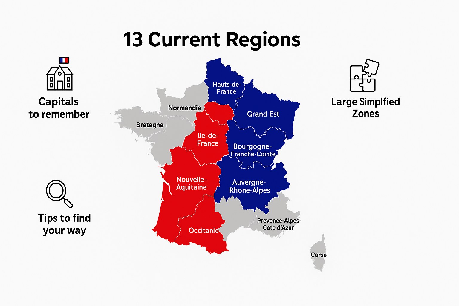
🏙️ The names and regional capitals to memorise
France has famous zones like Brittany or the Île-de-France. You’ll also find Occitania and Normandy. Each territory has a main city called the regional capital.
The North is at the top of the map. The South is right at the bottom. Paris is the capital and the heart of the Île-de-France. These landmarks help you not to get lost.
You need to place these names well. That’s the secret to doing well in your geography exercises.
Here is the full list of the 13 mainland regions with their regional capital, worth knowing to read a map of France well:
| Region | Regional capital |
|---|---|
| Auvergne-Rhône-Alpes | Lyon |
| Bourgogne-Franche-Comté | Dijon |
| Brittany | Rennes |
| Centre-Val de Loire | Orléans |
| Corsica | Ajaccio |
| Grand Est | Strasbourg |
| Hauts-de-France | Lille |
| Île-de-France | Paris |
| Normandy | Rouen |
| Nouvelle-Aquitaine | Bordeaux |
| Occitania | Toulouse |
| Pays de la Loire | Nantes |
| Provence-Alpes-Côte d’Azur | Marseille |
Corsica is an island in the Mediterranean Sea, to the south-east of mainland France. It’s the only French region that is entirely an island. Its capital, Ajaccio, is also the birthplace of Napoleon Bonaparte. Its landscapes mix mountains, scrubland and beaches, which makes it a unique region among the 13.
📐 Why some regions became very big
The old zones were grouped together to form large blocks. Nouvelle-Aquitaine is now enormous on the map. It’s a huge block that’s very easy to spot at a glance.
They simply stuck pieces of territory together. The idea is to be stronger, a bit like a simplified jigsaw. It’s more practical for organising things on a big scale.
Redrawing the map of France made it possible to create larger regions to compete better with our European neighbours.
📝 Simple tricks to spot them on paper
I suggest using bright colours for your colouring. Giving each zone its own colour helps the brain enormously. Use blue for the ocean and green for the land.
Look for familiar shapes in the outline. Brittany looks like a pointy nose poking out towards the sea. Mainland France has six clear sides, like a hexagon. Watch out for the mountains and borders too.
You can check the official administrative map to test your knowledge. It’s an excellent starting point for practising with a printable map of France’s regions for children.
🏝️ The 5 overseas regions far from mainland France
But France doesn’t stop at the borders of Europe. It stretches well beyond the oceans.
🌴 Guadeloupe, Martinique and Guiana in the Americas
Guadeloupe and Martinique sit in the heart of the Caribbean. French Guiana, for its part, is in South America. These are magnificent and truly far-off territories.
You’ll find regional capitals there like Cayenne or Fort-de-France. They are officially overseas departments and regions. The laws applied there are exactly the same as in Paris, despite the physical distance.
Here are the main cities to remember for your fact sheets:
- Guadeloupe (Basse-Terre)
- Martinique (Fort-de-France)
- French Guiana (Cayenne)
🌊 Réunion and Mayotte in the Indian Ocean
You have to look towards Africa to find these two islands on a world map. They are quite close to the continent. Réunion, by the way, is famous for its very active volcano.
Their geographical positions are very precise in the Indian Ocean. Mayotte is a slightly smaller archipelago. They are real pieces of France nestled under the tropical sun.
We sometimes forget that, despite the distance, French is spoken there. The children there go to school every morning, exactly like you do on the mainland.
🌐 French territories in every corner of the globe
The variety of landscapes is incredible across these lands. Between the Amazonian jungle and the blue lagoons, the scenery changes completely. France is therefore present all over the world.
These zones are precious for scientific research. They make it possible to study the stars or wild nature. It’s a real bonus for the country. Use a world map to place them properly.
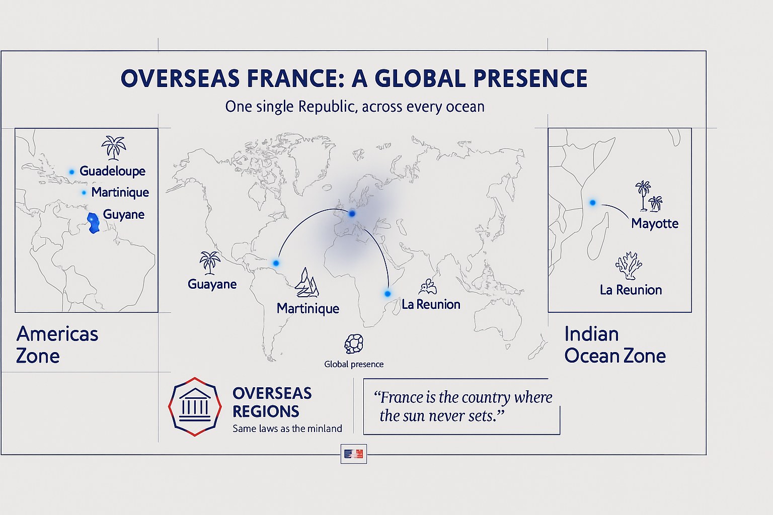
France is said to be the country where the sun never sets, thanks to its overseas territories.
To help your little explorers remember all this, feel free to look for a printable map of France’s regions for children. It’s perfect for picturing these far-off destinations.
🗺️ How to tell a region from a department
So you don’t get your wires crossed, you need to understand how these big spaces are divided into smaller pieces.
👨👩👧 The role of the region in children’s lives
The region mainly takes care of secondary schools (for older students). It also runs the regional trains. It’s the region that funds the big projects across the territory.
It also works for the local economy. It helps businesses grow. It’s a large organisation designed to make citizens’ daily lives simpler.
| Level | Main role | Real example |
|---|---|---|
| Region | Upper secondary schools and transport | Regional trains |
| Department | Lower secondary schools and roads | Maintaining local roads |
| Town | Primary schools | School canteen |
🔢 Department numbers to find your way more easily
We use numbers to identify the zones. The number 75 stands for Paris and 13 for Marseille. It’s very handy for number plates.
Several departments together make up a region. It’s like little boxes tidied away inside a bigger box. The way it’s divided is really logical.
What is the number of your own department? Find it quickly on your printable map of France’s regions for children!
🏘️ How towns are organised within the territories
You need to pick out the regional prefecture. It’s the “chief” town of the territory. The other big towns also play an important local role.
Every village belongs to a department. The department itself belongs to a region. It’s a simple hierarchy to remember to understand how the territory is organised.
In short, everyone has their place in this big French administrative scheme.
🆕 The new face of France since 2016
If your parents learnt a different map, that’s normal: everything changed a few years ago.
📜 The simplified story of the territorial redrawing
The State decided to merge the zones. Before, there were 22 regions on the mainland. That was sometimes a little too small.
It went down to 13 regions to bring forces together. The idea was to save money. The map became easier to read. It was an important historic change.
So in 2016, France got a fresh new look with this new design.
🔗 The old regions that merged with one another
Take the example of Alsace and Lorraine. They joined Champagne-Ardenne. Together, they now form the Grand Est.
Occitania was born from the marriage of two zones. It helps you understand the roots of the names. It’s a mix of cultures and histories.
Here are a few new entities:
- Grand Est
- Hauts-de-France
- Occitania
- Nouvelle-Aquitaine
🎯 The aim of this big administrative transformation
The goal was to make the regions stronger within Europe. They have more weight when it comes to decisions. It’s a matter of efficiency for everyone.
It makes large-scale decisions simpler. Fewer chiefs, but more powerful regions. The look of school textbooks changes. It’s more modern this way.
That’s why your printable map of France’s regions for children no longer looks like your grandparents’.
📍 5 geographic landmarks to enrich your map
To become a real geography pro, you need to add a few natural details to your drawing.
🏞️ The 5 great rivers that cross the country
Trace the Seine, which flows through Paris. The Loire is the longest river. The Rhône runs down towards the Mediterranean Sea.
Spot the Garonne in the south-west. The Rhine marks the border with Germany. Rivers often act as boundaries between the regions. It’s an essential visual landmark.
Learn to draw them to bring your map to life.
⛰️ The mountain ranges for little explorers
Place the Alps and the Pyrenees. The Massif Central is in the middle of the country. These are high-altitude zones.
Add the Jura and the Vosges in the east. Link these mountains to the regions. Savoy is in the Alps, for example.
Mountains change the climate and the activities of the people who live there.
🧀 The symbols and specialities of our local areas
Show the famous regional coats of arms. Each zone has its own flag. It tells an old and fascinating story.
Link a landmark to each zone. The Eiffel Tower for Paris, the volcanoes for Auvergne. Geography comes alive with these elements. It’s easier to remember.
Use a detailed map of the departments and regions to help you.
🖨️ Printable resources for learning while having fun
Now that you know everything, let’s take action with handy tools to download.
📥 Download a blank map to practise
Offering a PDF format without the names is still the best option. It’s ideal for testing your memory effectively. Print several copies to make progress every day.
Encourage your child to write the names themselves. Use a pencil so you can rub out small mistakes. It’s an excellent visual memory exercise with this blank map.
It’s also worth looking at educational geography resources from official mapping institutes. They are very useful.
🖍️ Educational colouring of the French regions
Using a black-and-white version makes things much simpler. The outlines need to be nice and clear so you don’t go over the edges. It’s a calm, creative activity.
Suggesting a precise colour code really helps you find your way. Red for the North, yellow for the South. It helps fix the images for the long term.
Turning learning into a game changes the whole experience. It’s much more fun than reading a plain school book.
🧠 A little quiz to test your knowledge
Ask questions about the regional capitals. What is the capital of Brittany? Where is Corsica on the map?
Making up a guessing game makes the moment friendly. Which region is shaped like a boot or a square? Check what’s been learnt in a playful way. It’s the final reward.
- Name 3 regions.
- What is the capital of the Grand Est?
Thanks to jigsaws and colouring pages from educational websites, memorising the 13 regions and their capitals becomes child’s play. Print out your map of France quickly to turn geography into a creative adventure. Your little explorers will be proud to master their territory while having fun!
❓ FAQ
🔎 Where can you find a printable map of France’s regions for children?
To find what you’re after, I suggest browsing websites dedicated to educational games. Many of them offer very varied PDF versions, with or without the names of the departments, the prefectures and even the rivers.
These resources are perfect for activities at home. They let younger children picture French geography while having fun with felt-tips or coloured pencils.
🔢 How many regions does France have today?
Since the territorial reform of 2016, mainland France is divided into 13 large regions. That’s slightly fewer than before, because some zones merged to become stronger and simpler to manage on a European scale.
You mustn’t forget the 5 lovely overseas regions: Guadeloupe, Martinique, French Guiana, Réunion and Mayotte. In total, that gives us 18 French regions to know inside out!
🏛️ What are the names of the new regions and their capitals?
No need to panic, the list is easy to remember. You’ll find, for example, Occitania (Toulouse), the Grand Est (Strasbourg), Nouvelle-Aquitaine (Bordeaux) or Brittany (Rennes). Each region has its capital, which is the main town where the important decisions are made.
For children, the trick is to match each name to a colour on a blank map. It’s far more meaningful than plain, rather dull lists of names.
⚖️ What is the difference between a region and a department?
It’s a question children often ask! To keep it simple, the region is a big zone that mostly looks after upper secondary schools and trains. The department is a smaller piece, inside the region, that handles things like lower secondary schools and roads.
It’s a bit like boxes of different sizes tidied away inside one another. Departments are often identified by their number, like 75 for Paris or 13 for Marseille, which really helps you find your way on number plates.
🔄 Why did the way the regions are divided change in 2016?
The idea was to simplify what is sometimes called the “administrative layer cake”. By going from 22 to 13 regions on the mainland, the State wanted to create larger, more competitive territories alongside our European neighbours. That’s why your map no longer looks quite like the one in your own school memories!
Some mergers gave birth to very big zones, like Nouvelle-Aquitaine or the Grand Est. Even though it sometimes shook up local habits, it now makes for a more modern, easier-to-read organisation.