
Explaining geography without a visual aid quickly becomes a headache for parents and a chore for little ones. 🌍 Our guide offers printable worksheets for kids covering the continents and the oceans, to turn this theory lesson into a fun moment to share together. You’ll find colourful maps, Montessori nomenclature cards and colouring activities to help children memorise our blue planet for good while having a great time.
- Why our Earth is a blue planet
- The six continents to know by heart
- The five oceans around us
- Finding your way with Earth’s lines
- Our ready-to-use teaching resources
- Fun ideas to remember it all
🌍 Why our Earth is a blue planet
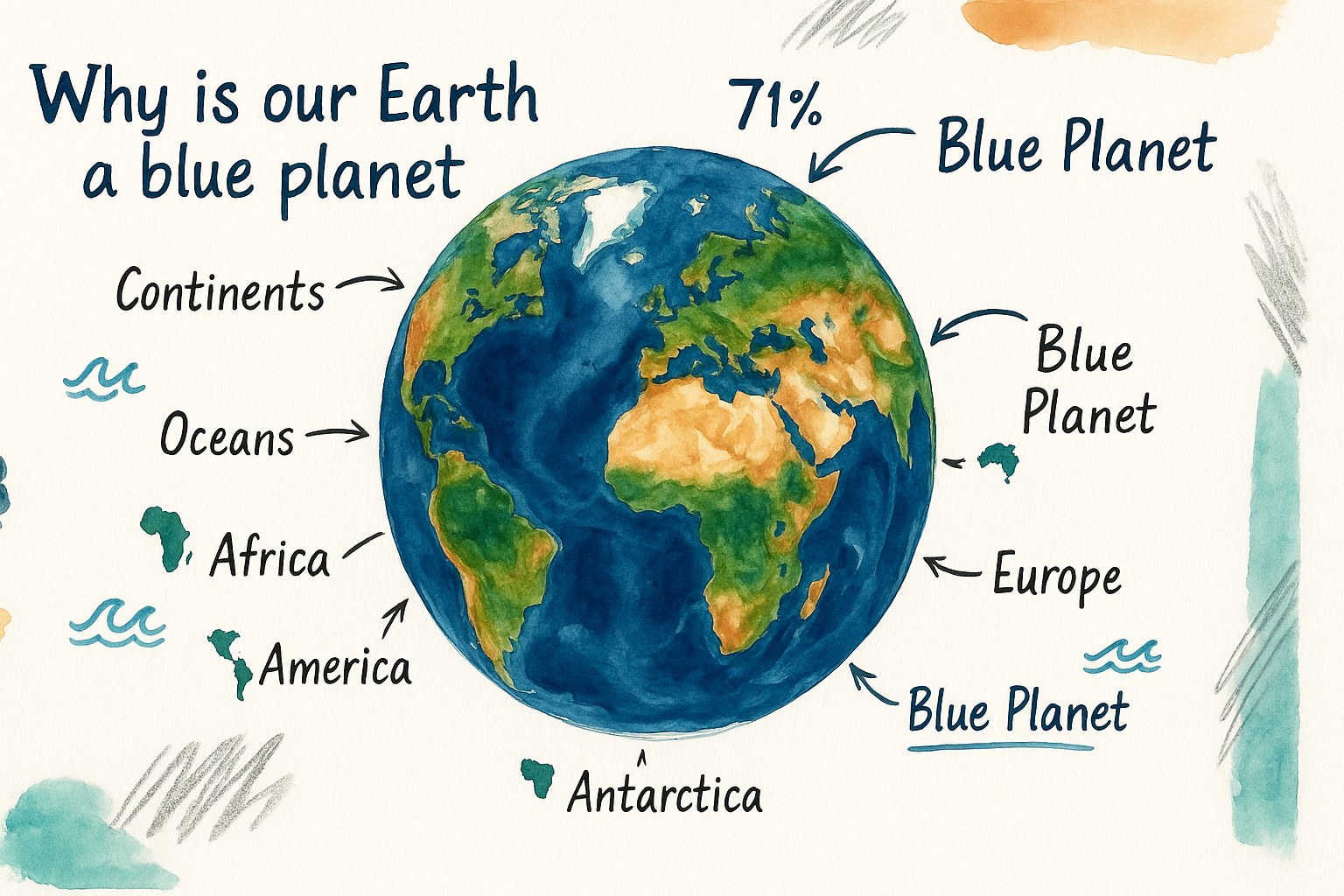
Once you take a good look at the globe, you quickly notice that water dominates, which helps us understand why we use such a colourful nickname for our home.
💧 How much of the globe is water
Seas and oceans cover about 71% of the surface. That’s a huge proportion compared with the land. This liquid omnipresence shapes the overall look of the Earth. Blue becomes the dominant colour of the scenery.
Astronauts see a gorgeous azure sphere from space. That famous image is exactly why we use the nickname “blue planet”. This view highlights the vital importance of water for us humans.
Water is everywhere. It shapes our landscapes and our climate every single day.
🟫 Telling land blocks apart from bodies of water
A continent is a huge stretch of land surrounded by water. It’s the solid base where we live. Children need to picture these massive, very stable blocks.
Oceans are vast, permanent stretches of salt water. Unlike the ground, water is moving and deep. There is in fact a real difference in relief between continents and oceans.
The continental crust is very old and varied. It rises far higher than the floor of the marine depths.
🔢 The official number of continents to remember
The count varies from one culture to another. Some countries group the Americas into one. Others separate Europe from Asia using precise geographical criteria.
The classic school model teaches six continents. We usually count Africa, America, Antarctica, Asia, Europe and Oceania. That’s the foundation for acing geography exercises.
Here are the names to memorise:
- Africa
- America
- Antarctica
- Asia
- Europe
- Oceania
For practice, using printable worksheets for kids about the continents and oceans helps to fix these names in mind while having fun.
🗺️ The six continents to know by heart
Now that we know what a continent is, let’s explore what makes each of these six giants of dry land special.
🏔️ What makes the great land masses unique
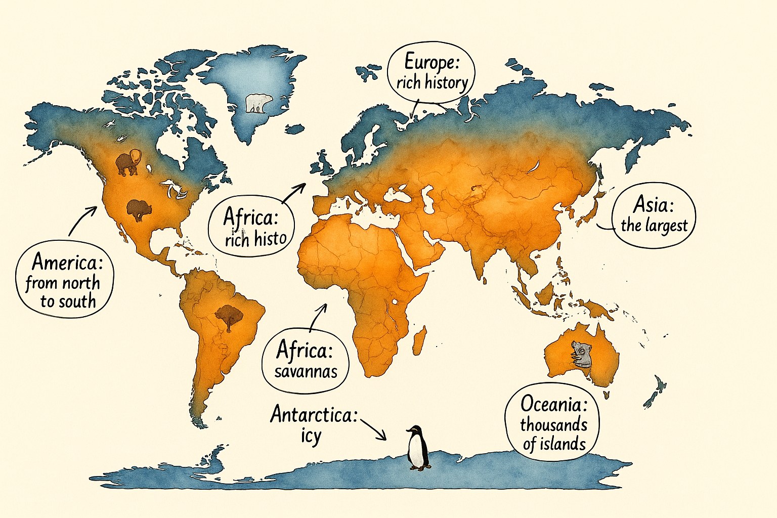
Asia is the largest and most populated. Africa is famous for its hot climate and its savannas. Europe has a rich history despite its small size. America stretches from north to south between two oceans.
Each zone has its own climate. We go from the ice of Antarctica to the scorching deserts of African lands.
Asia alone makes up nearly a third of our planet’s dry land, home to a uniquely diverse range of landscapes.
🏝️ The case of Oceania and its islands
Oceania is a special continent made up of thousands of islands. Australia is its biggest part. It’s a whole world surrounded by the waters of the Pacific.
You’ll find varied archipelagos there, such as Polynesia or Melanesia. The biodiversity is exceptional and very fragile. Sea landscapes dominate the daily life of the people who live there.
It’s the smallest of the continents. And yet, its maritime expanse is one of the largest in the world.
📏 Comparing the surface areas of the continents
Asia leads the ranking by far in surface area. It’s followed by America, then Africa. Antarctica is still bigger than Europe and Oceania, despite having no permanent inhabitants.
Picturing these sizes helps you remember the proportions. Europe looks small next to the Asian or American giant.
| Continent | Rank | Feature |
|---|---|---|
| Asia | 1st | Largest |
| America | 2nd | Long stretch |
| Africa | 3rd | Cradle of humanity |
| Antarctica | 4th | Frozen |
| Europe | 5th | Historic |
| Oceania | 6th | Maritime |
To help your little explorers, using printable worksheets for kids about the continents and oceans is a brilliant idea. It’s hands-on and far more fun!
🌊 The five oceans around us
If the continents are our anchors, the oceans form a huge liquid network that links them all together.
🌊 Locating the great sea basins
The Pacific is the largest of all the oceans. The Atlantic separates Europe from America with its powerful currents. The Indian Ocean lies mainly in the southern hemisphere.
Let’s not forget the Arctic in the north and the Southern Ocean in the south. They surround the poles with their icy waters. These reference points are essential for reading a school world map correctly.
Placing these names takes practice. Use the coasts of the continents as natural visual guides.
⚖️ The difference between a sea and an ocean
A sea is smaller and shallower than an ocean. It is often partly surrounded by land. The Mediterranean is the best-known example for pupils.
Oceans are vast basins that separate the continents. They all connect to one another. Seas can be closed off or open onto these great bodies of water.
The depth also changes radically between the two. The ocean depths reach impressive records beneath the surface.
🧂 Why salt water is so useful for the planet
Oceans regulate the world’s climate thanks to sea currents. They carry heat from tropical zones towards cold regions. Without them, temperatures would be extreme. They also absorb a large part of the carbon dioxide in the air.
Marine biodiversity is immense and still little known. Thousands of species live in these protective, life-giving waters.
Sadly, pollution threatens this balance. Plastic waste building up at sea is a serious problem for ocean life.
🧭 Finding your way with Earth’s lines
So that we don’t get lost on these huge surfaces, people have drawn imaginary lines that are very handy for finding our bearings.
🌐 The role of the equator and the poles
The equator is an imaginary line that wraps around the middle of the Earth. It splits the globe into two equal halves. That’s where the sun heats up the most.
The North and South Poles are the extreme points. They mark the axis of rotation of our blue planet. They are the coldest zones in the whole world.
These markers help us understand global geography. They serve as the basis for every world map.
🌗 Understanding the two hemispheres
The Northern Hemisphere is above the equator. The Southern Hemisphere lies below it. England, for example, sits in the northern part of the globe.
The seasons are reversed. When it’s summer in the north, it’s winter in the south. That’s an important idea for understanding the rhythm of the Earth.
This split also affects the sea currents and the winds. It’s a simple but fundamental natural arrangement.
🌍 Choosing between a flat map and a globe
A globe shows the Earth in three dimensions and as a sphere. It’s the truest picture of reality. A flat map, on the other hand, lays everything out on a sheet. It lets you see all the continents at once.
The flat map is more practical for classroom work. You can write on it and spot the names easily. The globe helps you understand the Earth’s rotation better.
The two tools complement each other. They offer different perspectives on our world.
To help your little explorers memorise all of this, don’t hesitate to use printable worksheets for kids about the continents and oceans. They’re a fun resource that turns geography into a real piece of child’s play.
📋 Our ready-to-use teaching resources
To move from theory to practice, nothing beats hands-on tools to handle in class or at home.
🗺️ Blank maps for practice
A blank map contains no written names. The child has to place the continents and oceans themselves. It’s a great exercise for testing visual memory.
Use colour codes to help with finding places. Blue for water and green for land. This makes it easy to tell the bodies of water apart from the land blocks.
Repeating this exercise several times guarantees lasting memorisation. It’s a timeless classic of geography lessons.
🌟 Montessori nomenclature and visual aids
Montessori nomenclature cards encourage independence. The child matches an image to a written name. It’s a gentle, effective method for learning geographical vocabulary.
These visual aids make abstract concepts very concrete. You can touch the cards and sort them into categories. This strengthens the connection between the eye and the brain.
Physically handling the cards helps the child anchor the names of the continents in their memory in a playful way.
📚 Worksheets suited to every primary level
For the youngest children, the worksheets are simplified. We focus on the main names and the colours. For older pupils, we add details like climates or relief. Every school level finds a challenge that suits them.
The identity cards for each continent are very popular. They sum up the essentials to remember for each major zone.
Here’s what you’ll find in our pack of printable worksheets for kids about the continents and oceans:
- worksheets for younger children (simple levels)
- worksheets for older children (technical details)
- answer keys included
🎲 Fun ideas to remember it all
Learning geography doesn’t have to be boring, so here are a few tips to turn revision into game time.
🎲 Board games and geography quizzes
Organise a quick family quiz. Who’ll be the first to place the Indian Ocean on the map? This kind of challenge grabs children’s attention straight away.
Board games let you travel virtually. You discover countries while staying in your bedroom. It’s a fun way to revise your lessons without even realising it.
Ask questions about world records. Which is the deepest ocean or the coldest continent?
📋 Tips for long-lasting worksheets
Laminating your documents is an excellent idea. It lets you use wipe-off markers as much as you like. The child can make a mistake and start again as many times as they want.
The worksheet then becomes a resource you can handle over and over. It’s more eco-friendly and cheaper in the long run. You can even create little games with velcro.
Store your resources in a dedicated binder. They’ll stay clean and ready for the next revision session.
🏛️ Linking landmarks and animals to the land
Linking a kangaroo to Oceania makes geography concrete. The Eiffel Tower instantly brings Europe to mind for a child. These cultural and natural symbols act as solid anchor points. They turn abstract names into living realities.
You can also use famous landmarks. The pyramids of Egypt instantly place Africa on the mental map. Printable worksheets for kids about the continents and oceans then become real visual tools.
- Kangaroo (Oceania)
- Eiffel Tower (Europe)
- Pyramids (Africa)
- Panda (Asia)
These printable worksheets about the continents and oceans turn geography into a captivating visual game. By handling maps and colouring pages, your children finally memorise the shape of the world with pleasure. Download these teaching resources quickly to give your little explorers a clear, lasting picture of our beautiful blue planet.
🎬 Watch the video
❓ FAQ
🔢 What is the exact number of continents for children to learn?
The number of continents can vary depending on school models and cultures. In our teaching worksheets, we generally use the six-continent model: Africa, America (which groups North and South together), Antarctica, Asia, Europe and Oceania. It’s a solid foundation to help pupils find their bearings on a world map.
It’s worth noting that some curricula prefer to separate the two Americas, bringing the total to seven. The key thing is to choose one model and stick to it so we don’t tie our little explorers up in knots!
🌊 How can I simply explain the difference between a sea and an ocean?
To keep it simple, the ocean is the “big boss”: it’s huge, very deep and borders the continents. Seas are smaller and often nestled near land, like the Mediterranean. You can tell children that seas are a bit like rooms in a house, while the oceans are the big corridors that connect them all.
Another handy tip is about salt: sea water is often saltier than ocean water because it evaporates faster in these smaller spaces. It’s a detail that curious minds often find amusing during geography lessons.
🔵 Why is the Earth called the blue planet?
It’s a nickname that comes straight from space! When astronauts look at the Earth, they see a gorgeous azure sphere. This is because seas and oceans cover about 71% of the globe’s surface. Water is therefore far more present than the dry land we walk on.
This liquid omnipresence gives that very particular dominant colour. It’s an excellent way to help children understand the vital importance of water for our environment and our everyday climate.
🗺️ What is the largest continent in the world?
It’s Asia that takes the gold medal for surface area! It alone makes up nearly a third of our planet’s dry land. It’s a giant continent that is home to an immense diversity of landscapes, from the highest mountains to the vastest plains.
In the ranking, it’s followed closely by America, then Africa. By contrast, Oceania is the smallest of the continents, even though its maritime expanse with all its islands is truly impressive.
🧠 How can I help a child memorise where the oceans are?
Using blank maps to colour in is magical for visual memory. By linking each ocean to a precise zone of the world map, the child creates their own reference points. For example, the Pacific is the giant that borders Asia and America, while the Atlantic separates Europe from the new world.
You can also use little matching games with animals: the penguin for the Southern Ocean or the whale for the cold waters of the Arctic. Handling visual, playful aids makes learning far less abstract and a lot more fun!
